
New Mineral Exploration Permits (applied for)
posted on
Oct 24, 2019 10:19PM

Combining Classic Mineral Exploration with State of the Art Technology

With news of new Mineral Exploration Permits as well as some details from Mr. Gross I have been wondering where new MEP land will be, and have been looking around for some data and maps. Bear with me on this, it jumps around a bit between a few sources.
The following link is from the Arizona State Land Department:
ASLD Parcel Viewer - gis.azland.gov/webapps/parcel/?loc=-109.9927,31.6420,14&layers=11,3,0
You can see the claims held by Liberty Star at present, the roughly 10.4 acres. This is where we will eventually see the new MEPs pending approval.
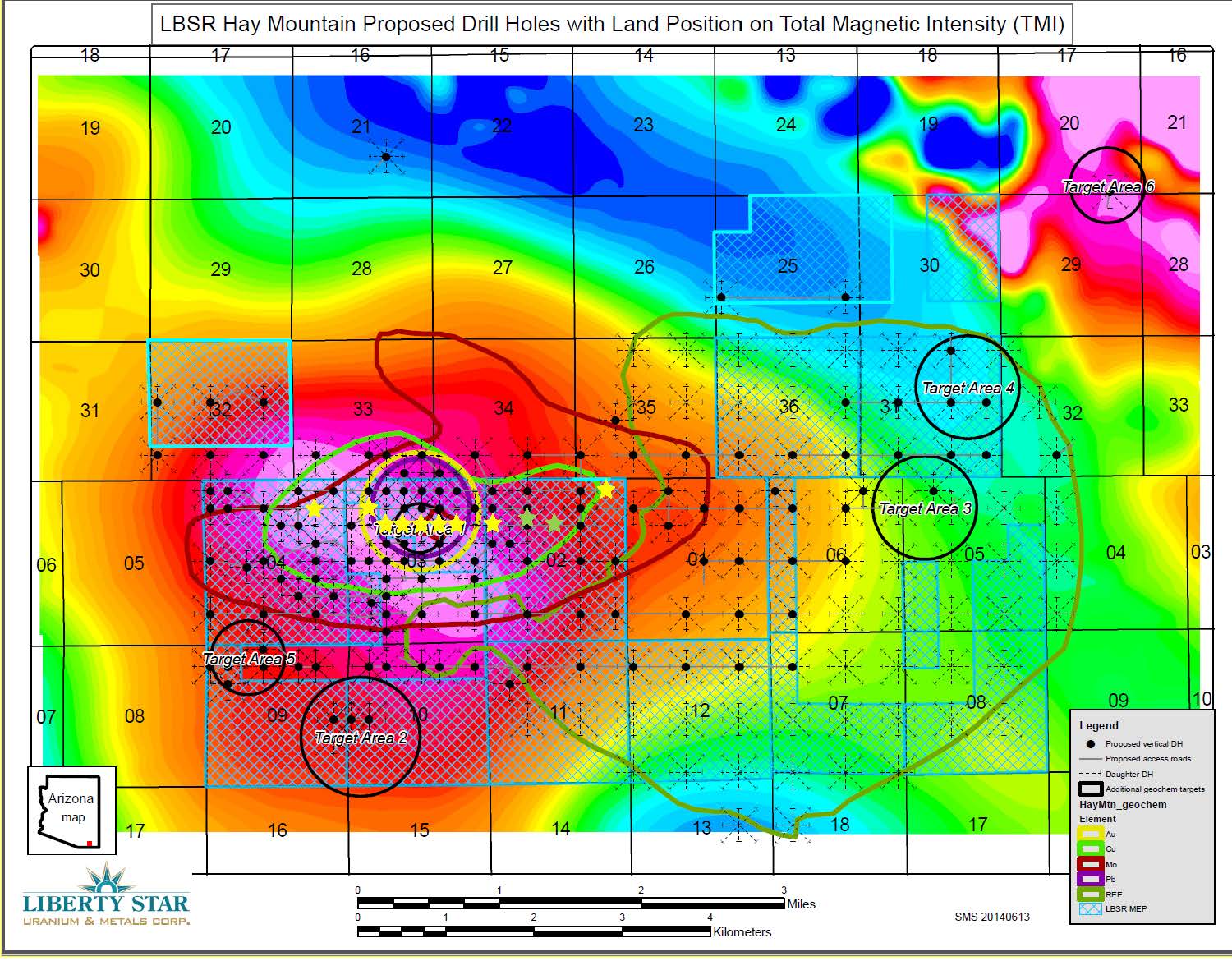
Seeing this reminded me of an image from the LBSR website showing ZTEM data derived "Total Magnetic Intensity", and specifically 6 target areas for drilling. That image is here:
TMI - https://www.libertystaruranium.com/wp-content/uploads/2015/10/REDACTEDHay-Mtn-Project.-ASLD-Drilling-Plan-Of-Ops-for-10-drill-holes-10.20.2015_Page_05.jpg
After georeferenceing an export of that ASLD map and the TMI image an overlay was created to compare the existing MEPs with the TMI image. I'd like to share the overlay image, but I don't know how to do that here, and am not sure about copyright infringment if I post it elsewhere. Anyway, cross referencing the image above with ASLD you see the LBSR MEPs from 2015 (blue hatching) were more extensive to the South and East (Sections 11-12-07-08, then North a few sections). Those areas, no longer permitted to LBSR, were in areas with less "Magnetic Intensity". I am guessing that is why those are no longer held by LBSR.
The newer MEPs from Oct 15 2018 (http://www.libertystaruranium.com/2018/10/15/liberty-star-adds-land-pays-hay-mountain-federal-claim-fees-2018-2019/) can be seen as the northern block in the ASLD maps. Go back to the TMI image and you can see the newer MEP areas are in the pink-red-yellow areas of "Greater Magnetic Intensity". These areas (Sections 33 and 34 specifically) are also part of what I assume Mr. Gross was talking about in his "first instance" paragraph. Continue North of there to sections 27-28-29 and look on the ASLD maps to see the northern block also abuts Public Rights of Way and the Tombstone Airport. Proximity to public R.O.W. and other transportation means unobstructed ingress/egress to these claims and reminds me of Mr. Gross' mention of needed offices and equipment maintenance facilities.
To concisely provide some conjecture of the new permit locations and wrap this up. Target Area 6 looks juicy (TMI map) but is also pretty far away. Which leaves me to think of what Mr. Gross said about not getting leveraged by competitors holding suitable locations of support operations. I think they will pick something suitable for heap leaching and a tailings pile, and this quote in particular, "Having access to such surface areas sufficient to support the mine operation throughout its life is essential to its long term viability".
Im excited to hear more from Mr. Gross and also the updated ZTEM data. I have been excited by this story since 2010 and not a day goes by that I do not check for updates. Still going long.