Here is a georeferenced couple of images of Sage vs. Hercules. Sorry for the low res but it's late and this one was just laying around:
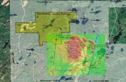
Hercules is the label on the RHS upper of the bright green KXL patch. The Golden Mile is the longest yellow line NW-SE near the LHS of the label. It was acknowledged as 2 km long in this early image, and now continues all the way to the Sage property and also extends I believe at the other end, to make the 5 k.
Interesting how the impression from the geomag may be understating the case.
