
Premier continues exploration success at Hasaga Red Lake
posted on
Jan 27, 2016 10:26AM

Red Lake and Geraldton are Canada's PREMIER addresses for gold

|
|
|||||||||||||||||||||||||||||||||||||||||||||||||||||||||||||||||||||||||||||||||||||||||||||||||||||||||||||||||||||||||||||||||||||||||||||||||||||||||||||||||||||||||||||||||||||||||||||||||||||||||||||||||||||||||||||||||||||||||||||||||||||||||||||||||||||||||||||||||||||||||||||||||||||||||||||||||||||||||||||||||||||||||||||||||||||||||||||||||||||||||||||||||||||||||||||||||||||||||||||||||||||||||||||||||||||||||||||||||||||||||||||||||||||||||||||||||||||||||||||||||||||||||||||||||||||||||||||||||||||||||||||||||||||||||||||||||||||||||||||||||||||||||||||||||||||||||||||||||||||||||||||||||||||||||||||||||||||||||||||||||||||||||||||||||||||||||||||||||||||||||||||||||||||||||||||||||||||||||||||||||||||||||||||||||||||||||||||||||||||||||||||||||||||||||||||||||||||||||||||||||||||||||||||||||||||||||||||||||||||||||||||||||||||||||||||||||||||||||||||||||||||||||||||||||||||||||||||||||||||||||||||||||||||||||||||||||||||||||||||||||||||||||||||||||||||||||||||||||||||||
| 1/26/2016 5:20:39 PM | |||||||||||||||||||||||||||||||||||||||||||||||||||||||||||||||||||||||||||||||||||||||||||||||||||||||||||||||||||||||||||||||||||||||||||||||||||||||||||||||||||||||||||||||||||||||||||||||||||||||||||||||||||||||||||||||||||||||||||||||||||||||||||||||||||||||||||||||||||||||||||||||||||||||||||||||||||||||||||||||||||||||||||||||||||||||||||||||||||||||||||||||||||||||||||||||||||||||||||||||||||||||||||||||||||||||||||||||||||||||||||||||||||||||||||||||||||||||||||||||||||||||||||||||||||||||||||||||||||||||||||||||||||||||||||||||||||||||||||||||||||||||||||||||||||||||||||||||||||||||||||||||||||||||||||||||||||||||||||||||||||||||||||||||||||||||||||||||||||||||||||||||||||||||||||||||||||||||||||||||||||||||||||||||||||||||||||||||||||||||||||||||||||||||||||||||||||||||||||||||||||||||||||||||||||||||||||||||||||||||||||||||||||||||||||||||||||||||||||||||||||||||||||||||||||||||||||||||||||||||||||||||||||||||||||||||||||||||||||||||||||||||||||||||||||||||||||||||||||||||
| Read Replies (1) of 115156 | |||||||||||||||||||||||||||||||||||||||||||||||||||||||||||||||||||||||||||||||||||||||||||||||||||||||||||||||||||||||||||||||||||||||||||||||||||||||||||||||||||||||||||||||||||||||||||||||||||||||||||||||||||||||||||||||||||||||||||||||||||||||||||||||||||||||||||||||||||||||||||||||||||||||||||||||||||||||||||||||||||||||||||||||||||||||||||||||||||||||||||||||||||||||||||||||||||||||||||||||||||||||||||||||||||||||||||||||||||||||||||||||||||||||||||||||||||||||||||||||||||||||||||||||||||||||||||||||||||||||||||||||||||||||||||||||||||||||||||||||||||||||||||||||||||||||||||||||||||||||||||||||||||||||||||||||||||||||||||||||||||||||||||||||||||||||||||||||||||||||||||||||||||||||||||||||||||||||||||||||||||||||||||||||||||||||||||||||||||||||||||||||||||||||||||||||||||||||||||||||||||||||||||||||||||||||||||||||||||||||||||||||||||||||||||||||||||||||||||||||||||||||||||||||||||||||||||||||||||||||||||||||||||||||||||||||||||||||||||||||||||||||||||||||||||||||||||||||||||||||
|
Premier continues exploration success at Hasaga Red Lake 11 hours ago ca.finance.yahoo.com
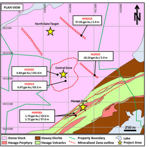
Shares Issued: 170,692,322 THUNDER BAY, ON, Jan. 26, 2016 /CNW/ - Premier Gold Mines Limited (TSX-PG) is pleased to provide its latest update from surface drilling, including final results from the 2015 program, on the Company's 100%-owned Hasaga Project in the Red Lake gold mining district of Northwestern Ontario. Drilling continues to extend near surface mineralization in the Hasaga Porphyry and Central Zone areas and is encountering encouraging initial results at the North Gate exploration target area. Highlights from the program include the following: The Hasaga Property is host to the past-producing Hasaga and Gold Shore Mines and is strategically-located proximal to the Balmer-Confederation regional unconformity, recognized as an important geologic feature at the multi-million ounce past and currently producing Red Lake area mines (See Figure 1). Tables 1, 2 and 3 provide a more comprehensive summary of highlight results from additional holes drilled at Hasaga. Recent highlights include the identification of a new near-surface mineralized zone in the footwall of the Hasaga Porphyry (noted as F1 in Table 1), expansion and infill-success in the Central Zone (provided in Table 2), and intersecting high-grade mineralization in exploration drilling (Table 3). Additional images profiling these results can be viewed utilizing the following link ( click here). Premier completed more than 60,000 metres of diamond drilling on the property during the 2015 exploration program, giving management sufficient confidence to approve a 2016 program expected to include an additional 50,000 metres of drilling. Premier also purchased adjacent lands that expanded the size of the property to some 1200 hectares. "We have high expectations for our follow-up program at Hasaga this year," commented Stephen McGibbon, Executive Vice-President, Corporate and Project Development on the Company's C-Suite Blog (http://www.premiergoldmines.com/news/c-suite-blog). "Our team will commence drilling on January 28th, following a planning workshop in Thunder Bay." An upgraded litho-structural model is being completed at the Hasaga Porphyry and Central Zone target areas that will be used to support the drilling plan for the coming year. The 2016 exploration program will include infill and step-out drilling, bulldozer stripping, mapping and channel sampling on relevant outcrop exposures, wedge drilling to test the continuity of recently identified high-grade gold mineralization, and additional step-out drilling along strike on the new property area. Initial metallurgical testing is also expected to be undertaken in 2016. Hasaga Porphyry Target The Hasaga Property is located along a "regional trend" that was host to multiple historic mines including the Hasaga, Howey and Madsen mines. The Phase 1 drill program included some 25,000 metres of drilling to test the Hasaga Porphyry target for widespread mineralization within the porphyry rock unit that was host to the Hasaga and Howey gold mines. Drilling has confirmed this target with multiple intercepts of mineralization as highlighted in Table 1 that are surrounded by broad haloes of lower grade mineralization (typically less than 0.60 g/t Au) which would result in some intercepts exceeding 100 metres in core length. Apparent gaps in the numerical "HOLE_ ID" sequence listed in Table 1 reflect those holes which don't contain higher grade composite intervals, but often do contain the lower grade haloes over variable widths. Table 1: Highlight Results From final drilling in the Hasaga Porphyry target
Central Zone Target The Central Zone Target is located where a series of conjugate structures occur within the Dome Stock, a large granodiorite rock unit in the heart of the Red Lake camp. A single hole drilled in this area in the 1980's by Lac Minerals reported wide spread mineralization that was not followed up. Premier drilling in 2015 confirms this open pit target (see Table 2 below) with multiple intercepts of wide-spread gold mineralization up to more than 100 metres in length. Table 2: Highlight Results From final drilling in the Central Zone target
Exploration Drilling Upon acquiring the Hasaga Property from Goldcorp in early 2015, Premier believed that Hasaga and Gold Shore underground mines (that ceased production in the early 1950's) had the potential to host gold mineralization that could be amenable to open pit mining methods in addition to higher grade underground mineable potential. The Red Lake Gold Shore mine, which saw limited historic production (grading 8.37 g /t Au), is situated within a structural corridor that has seen little exploration. Table 3 provides highlight results from recent drilling within the Gold Shore corridor including high grade mineralization (with visible gold) within a zone hosting multiple quartz veins that will be followed-up in the 2016 drill program. Table 3: Highlight results from exploration drilling
Stephen McGibbon, P. Geo., is the Qualified Person, has approved the information contained in this press release and is a Qualified Person within the meaning of National Instrument 43-101. Assay results are from core samples sent to either Accurassay Laboratories or Activation Labs, both accredited mineral analysis laboratories in Thunder Bay, Ontario, for preparation and analysis utilizing both fire assay and screen metallic methods. A quality assurance and quality control program (QA/QC) was implemented by Premier Gold Mines and the laboratory to insure the precision and reproducibility of the analytical method and results. The QA/QC program includes the insertion of standards, blanks and field duplicates in the sample batches sent to the laboratory and a systematic re-assaying of samples returning values above 5 g/t Au by fire-assay using a gravimetric finish. Premier Gold Mines Limited is one of North America's leading exploration and development companies with a high-quality pipeline of gold projects focused in proven, safe and accessible mining jurisdictions in Canada and the United States. The Company is well financed with approximately $75 million in cash and investments and a portfolio of advanced-stage assets in world class gold mining districts such as Red Lake and Geraldton in Ontario and the most prolific gold trends in Nevada. The statements made in this Press Release may contain forward-looking statements that may involve a number of risks and uncertainties. Actual events or results could differ materially from the Company's expectations and projections. SOURCE Premier Gold Mines Limited Image with caption: "Figure 1: Plan view of primary drill target areas at Hasaga (CNW Group/Premier Gold Mines Limited)". Image available at: photos.newswire.ca Contact: Ewan Downie, President & CEO, Phone: 807-346-1390, Fax: 807-346-1381, e-mail: Info@premiergoldmines.com, Web Site: www.premiergoldmines.com |